Earth’s Dynamic Processes: A Journey Through Plate Tectonics, Volcanoes, and Rock Formation
ERTH-2310E Exam 1 Cheat Sheet
Continental Drift and Plate Tectonics
The continents rise above the ocean because of isostasy. The continental plates are less dense than oceanic crust and thus sit higher relative to the oceanic plate.
3/5 Most abundant elements in the crust: Silicon, Iron, Oxygen, Aluminum, Calcium
The Geosphere and Biosphere are part of the Earth system.
Earth’s Spheres:
- Geosphere (tectonics and volcanism)
- Atmosphere (air)
- Hydrosphere (water)
- Cryosphere (glaciers)
- Biosphere (life)
- Asthenosphere (temperature structure, pressure gradients, global circulation, and regional patterns)


Climate refers to long-term weather patterns, while weather refers to short-term atmospheric conditions. Landscapes are shaped by Earth’s processes. Earth is not homogenous; it is layered and partitioned. Iron, oxygen, silicon, and magnesium are the most prominent elements. O2 and Si are most abundant in the continental crust, while N and O2 are most abundant in the atmosphere. Many geologic processes occur because of the chemical composition and internal structure of the Earth.
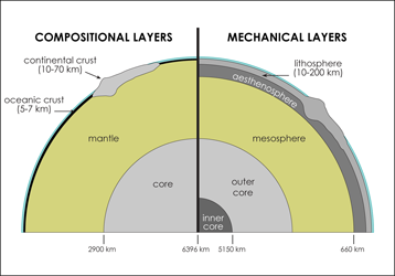
Earth’s Crust:
- Continental crust: lighter silicate minerals
- Oceanic crust: denser silicates
- Mantle: very dense
- Core: Fe and Ni
Landmasses rise above the sea because of the principle of isostasy. Thicker objects lie deeper compared to thinner objects (denser and thinner sink). Continental crust is thicker and more variable compared to oceanic crust (more dense). Therefore, oceanic crust sinks.
Earth’s Layers:
- Lithosphere: Hard, solid shell, rigid, brittle, breakable like cold butter, cold, strong outer layer.
- Asthenosphere: Ductile layer under the lithosphere, soft solid like warm butter, mid-part of the mantle, hotter, weaker inner layer.
- Mesosphere: Hard solid, lower part of the mantle.
- Outer Core: Liquid.
- Inner Core: Solid.
The lithosphere is detached from the asthenosphere, allowing for independent movement of tectonic plates. Therefore, physiography is organized.
Evidence of Continental Drift:
- Restored geographic fit of the continents.
- Similar geologic records between Brazil and South America.
- Rock types and geologic features: similarity across the North Atlantic.
- Records of past climate and environment that reflect geographic position.
- Biological fossils.
Sonar allowed for the study of the oceanic floor. Later, ocean floors were mapped, and ocean ridges were discovered. Rocks form along plate boundaries.
Paleomagnetism: Earth has a geomagnetic field generated by the spinning of the core. The magnetic field flips over time. Importance: New rocks formed with iron will form oriented towards the poles.
Mid-Ocean Ridges: Regionally elevated ridge above the seafloor (ores concentrated). The ridge gives crystallization (plates move rocks backward away from the ridge).
Other Technological Developments:
- Geophysical imaging of the crust and mantle (X-ray of inner structure).
- GPS to watch imagery and movement.
Plate Tectonics: Ocean basins exist because ocean crust is denser and thinner than continental crust. Tectonics is the movement of discrete segments of Earth’s rigid lithosphere in relation to one another.
Drivers of Plate Motion:
- Lithosphere: cool, strong outer layer.
- Asthenosphere: hotter, weaker layer.
Both are detached to allow for the movement of tectonic plates. Similar to boiling water, convection of the asthenosphere forms convection cells to release heat from the internal Earth.
Types of Plate Boundaries:
- Divergent: Two plates move apart, resulting in the upwelling of hot rock and magma from the mantle and the creation of new seafloor (like the Atlantic Ridge).
- Convergent: Where two plates come together, resulting in subduction or collision. Mountain belts are formed by compressive tectonic stress.
- Andean-type: Mountains formed due to the deformation of the continental plate.
- Himalayan-type: Mountains formed due to the collision between two continents.
- Subduction: Occurs between oceanic lithosphere and continental lithosphere, or two oceanic lithospheres. The denser one is pushed underneath.
- Collision: Occurs between two continental lithospheres (similar density, so they collide to form mountains).
- Transform Boundary: Where two plates move horizontally past one another (no production or destruction of lithosphere). Accommodate plate motion across Earth (San Andreas Fault).
Geological Time and Stratigraphy
Sedimentary layers tell time. Landscapes are shaped by processes over long or short periods. Events such as eruptions, floods, and other major storms can be dated and correlated.
Grand Canyon: Every 1000 feet, gain 3-5 degrees. The geologic map portrays the spatial distribution of rock types, river contours, and topography. The stratigraphic column shows levels. The oldest rocks are Zoroaster Granite and Vishnu Schist. Tapeats Sandstone is the base of continuous stacks of rock.
Stratigraphy: The study of strata or layers of sedimentary rock. It doesn’t tell the full story because of many holes in information (periods of erosion or lack of events). Kinds of materials, pressure, age information include minerals that crystallize from magma (eruption event), features that record cyclicity (tree rings and lake waves), organic material, sediments buried or exposed to cosmic rays, and fossils.
Dating Methods in Earth Science:
- Relative Dating Methods: Specify the ages of rocks and events based on their position relative to each other (rely on position relative to each other = spatial or geometric relationships with emphasis on stratigraphy, fossils, and cross-cutting).
- Numerical (Absolute) Dating Methods: Specify the age of rocks or events in the number of years with some level of analytical certainty.
- Radiometric Methods: Specify the number of years, advanced through physical and study of radioactive decay of heavy metals.
- Tree rings, lake sediments, and other chronologies that rely on annual cyclicity.
- Volcanic ash: event with a single age.
- Radioactive Decay: Naturally occurring unstable nuclides emit particles and energy to achieve stability (can measure a mineral’s time).
Biostratigraphy: Framework for the entire geologic timescale. A biostratigraphic unit is defined and characterized by fossil content. Stratigraphic range is the total vertical interval through which a species occurs in strata, from lower to uppermost occurrence.
Index Fossil: Commonly invertebrates (has to be abundant in the record to be found easily, easily distinguished, geographically widespread, occurs in many kinds of depositional environments, has a narrow temporal range (not a huge amount of time)).
Major Biotic Diversification and Extinctions: Sepkoski’s curve shows diversity patterns of major marine organisms from Cambrian to Tertiary time (5 or 6 major extinctions over time).
Subdivisions of Time:
- Millennium, century, decade, year, month, day.
- Geologic time: eon, era, period, epoch, stage, substage.
History of Life: First appeared 3.8 billion years ago. Algae at first, O2 from cyanobacteria built up in the atmosphere by 2 Ga. 542 Ma marks the first hard shells.
Periods of Geologic Time: Geology of the Grand Canyon. Metamorphic rocks intruded by granite. Tapeats Sandstone deposited on top of Vishnu Schist 500 Ma in the Cambrian (shallow water sandstone with evidence for bioturbation from soft-bodied invertebrates (only trace fossils, no hard parts), records Cambrian explosion of multicellular life, shows us that the southwest of North America was partially emerged in water (closer to the equator too)). Kaibab Limestone (top layer) Early Permian 290 Ma, shows the last of shallow seas that transgressed over the Zion region throughout the Paleozoic era. Marine fossil fragments and limestone composition indicate shallow marine, new shore, warm and arid climate.
Stratigraphic Correlation: National Parks of Arizona and Utah. Formations can be traced long distances (overlap is seen in sequences of rock).
Pinnacles National Park and the San Andreas Fault
Pinnacles: Ancient volcano transported northward by transform faulting and tectonic plate motion.
San Andreas Fault System: Right-lateral transform fault system. Pinnacles National Park: volcanic and volcanoclastic rock. Volcanic formation formed 23 Ma during a period of volcanic eruptions. Magma was rhyolitic in origin. The formation consists of rocks such as banded and massive rhyolite, some andesite and dacite, and various pyroclastic units. High peaks consist of a strong, consolidated type of volcanic breccia. Layers tend to form clastic volcanic rocks (rhyolite and dacite) through autobrecciation, which occurs when the nearly solid lava breaks up into blocks and then is reincorporated with the lava flow again and mixed in with the remaining liquid magma. The resulting breccia is uniform in rock type and chemical composition.
Volcanic Breccia: Large variation in angular clast sizes, but the hot ash and gases from the original eruption fuse together and the matrix and form a strong rock. Evidence of geochemically identical volcano identified farther south of California. The volcano was split in half after its eruption.
Pinnacles and the San Andreas Fault Stages of Development:
- Volcanic eruption of the Pinnacles and Neenach volcanoes during subduction of the Farallon Plate beneath the North American continent.
- Volcanism ceased once the plate boundary evolved into a transform fault (San Andreas Fault).
- The San Andreas Fault localized through the Pinnacles volcanoes, slicing it in half. Pinnacles rocks were retained on the Farallon Plate, and the Neenach rocks on the North American Plate.
Pinnacles records long-term fault motion of the San Andreas Fault since 23 Ma. Displacement of the Pinnacles from its origin point since 23 Ma is a testament to the longevity of the San Andreas Fault in modifying the geography of the West Coast.
Markers of Long-Term Lateral Fault Motion:
- Slip Rate: Rocks slipping past each other (4 mm/year or 4 km/Ma), an important input to seismic hazard and risk assessments.
- Horizontal Fault Motion: Measurable surface record of plate boundary deformation (short-term: offset streams, sedimentary deposits, or landforms; long-term: reconstructed distinct depositional zones, intrusive rock bodies, or other geologic features).
Faulting and Earthquakes
The San Andreas Fault is a transform fault with localized compression and extension forming mountain ranges and valleys that generally parallel the plate boundary.
What is an Earthquake? Ground shaking caused by the sudden and rapid movement of one block of rock sliding past another. Rocks slide past one another along fractures in the crust called faults. Most earthquakes occur along pre-existing faults. Stored-up energy is released as seismic waves that radiate in all directions from the focus (hypocenter).
Topographic Expression of Faulting: Borrego Fault: 1.5-meter high surface rupture (fault scarp) formed in just seconds during an earthquake (bigger earthquake = bigger scarp).
Earthquakes cause ground motion and measurable surface fault offset.
Seismic Waves and Ground Motion: Waves of energy caused by the sudden breaking of rock within the Earth or an explosion. They are the energy that travels through the Earth and is recorded on seismographs.
Two Types of Waves:
- Surface Waves: Only move near the surface of the planet like ripples on water.
- Body Waves: Travel through Earth’s inner layers.
- Primary Waves (P-waves): Compression waves that can travel through all materials (like a slinky).
- Secondary Waves (S-waves): Can only travel through solid material like a rope motion.
Earthquake Wave Arrival Sequence: First wave P-wave arrives, followed by the first S-wave, and then surface waves.
Earth Materials
Composition of Earth’s Crust: Made up of O2 and Si (silicate minerals).
Mineral: A naturally occurring solid that possesses an orderly crystalline structure and a definite chemical composition.
Rock: An aggregate mass of naturally occurring minerals or noncrystalline matter.
8 Major Groups of Minerals:
- Silicates: Most of the crust, most common.
- Carbonates: CO32- (important in marine and cave environments).
- Phosphates: Combine with PO4 with others (sources of fertilizer).
- Sulfates: SO42- (metal cation bonded to a sulfate anionic group – many forms by evaporation of seawater).
- Halides: Cl or F (sulfates and halides are important in evaporative environments).
- Oxides: Metal cations bonded to O2, important in weathering environments (rust).
- Sulfides: Metal cations bonded to a sulfide anion.
- Native Elements: Minerals made up of a single metal (gold, Au, Ag, Cu).
Other Substances:
- Mineraloids: Substances with more complex origins that do not fit neatly into other groups (commonly biogenic, lack crystalline structure [opal and amber]).
How Do Minerals Form? 5 Ways:
- Crystallization from a Melt: Crystals grow when melt cools (atoms bond during the transition from liquid to solid phases).
- Precipitation from an Aqueous Solution: Minerals nucleate from seeds when a solution becomes saturated in dissolved ions.
- Precipitation from a Gaseous Solution: When a gas becomes saturated in dissolved ions.
- Biomineralization: (Teeth, bones, shells).
- Solid-State Diffusion: Mobile elements in existing minerals can move to form new crystals without remelting.
Examples of Mineral Formation:
- Silicates, halides, sulfates, carbonates.
- Sulfates, sulfides, carbonates, silicates.
- Carbonates, phosphates, silicates.
- Silicates, phosphates.
Why Study Minerals? Building blocks of Earth and important to humans because of industrial, ore, and gem minerals.
Most Abundant Silicate Minerals:
- Less dense, lighter: Quartz, orthoclase feldspar, muscovite mica, biotite mica.
- Dense, darker: Amphibole, pyroxene, olivine.
3 Major Rock Types:
- Igneous (Crystals): Formed by the cooling of molten magma/lava.
- Sedimentary (Grains): Formed by erosion, transport, and deposition of sediment.
- Metamorphic (Fabrics): Formed by the alteration of rock due to increased temperature or pressure.
Why Are Eruptions So Different? Low silica vs. high silica. Classification of igneous rocks by composition.
Magma consists of 3 phases:
- Melt (Liquid): Composed of mobile ions from Earth’s crust minerals.
- Crystals (Solid): Mainly silicate minerals.
- Volatiles (Gas): Dissolved components that vaporize at surface pressures (under pressure, help push magma to surface).
Silica is the thickening agent of magma. Eruptive style depends on silica content:
- Low silica: Runny and effusive.
- High silica: Thick and pasty and viscous.
Mount Rainier National Park
Stratovolcano: Large, classic-shaped volcano (symmetrical cone), composed of interbedded lava flows, volcanic mudflows, and layers of pyroclastic debris. Magma composition is typically intermediate silica content. Glaciated even at low latitude because of large elevation. Can fuel mudslides and feed into rivers (geometry of nearby rivers associated with the volcano).
Episodically Active: Began 1.5 Ma, last eruption 1000 years ago. Alternated between lava-producing and explosive debris-producing eruptions. Lahar: mud or debris flow.
Pyroclastic Eruptions and Pyroclastic Flows: Fast-moving current of hot gas and volcanic matter known as tephra that flows along the ground away from the volcano (1000°C and fast, up to 430 mph). The most deadly of all volcanic hazards. Speed depends on the density of the current, volcanic output rate, and gradient of the slope.
Lahars (Volcanic Mudflow): Hot water alters the volcanic rock to soft clays. Glaciers provide more water. The rock/water mixture speeds down the steep slopes. A lahar event can swell nearby rivers with fast-moving mud and rock-laden slurry.
Why Do Volcanoes Erupt? Sources of Earth’s Heat:
- Leftover from Earth’s formation (planetesimal accretion, gravitational compression, iron differentiation, Moon formation, meteorite bombardment).
- Ongoing heat generation (radioactive decay, primarily in the crust).
Generating Magma from Solid Rock: Crust and mantle composed of solid rock. Primary magma generated in the uppermost mantle. 3 ways to make magma:
- Heat rocks above melting temperature (heat derived from nearby magma sources can melt the surrounding rocks [in collision settings, intense heating during collision can generate magma]).
- Add water and reduce melting temperature (in subduction zones, the addition of water lowers the melting temperature [as the oceanic plate sinks, hydrous minerals release their water into the overlying mantle]).
- Decrease pressure of rocks (rocks’ melting temperature depends on pressure (melting temperature increases with increased pressure and Earth’s depths [removing overburden rocks, pressure decreases and melting temperature decreases]). Plate tectonics: hot but solid mantle rocks rise to regions of lower pressure, leading to melting (pressure drops when hot rock is carried to shallower depths).
3 Major Types of Rocks:
- Igneous: Cooling and solidification of molten Earth’s magma (extrusive igneous rocks cool quickly at the surface [lava flows or pyroclastic debris cool quickly], underground melt is magma, at the surface, lava, lava emerges as a volcano). Intrusive rocks cool slowly underground (more intrusive than extrusive [intrudes into pre-existing wall rock down under]).
- Sedimentary:
- Metamorphic:
Features in Parks at Subduction Zones
Convergent Boundary: Subduction of the Juan de Fuca Plate beneath the North American Plate to make the Cascade volcanoes. Accretionary wedge caused by when sedimentary and volcanic layers are scraped off the top of the subducting ocean plates and added to the edge of the continent. Forearc valleys (between two parallel mountain ranges – low lying area). Volcanic arc: the top of the subducting ocean plate reaches depths where it’s hot enough to generate fluids, so they melt and form an arc.
Why are the Cascades in a straight line? Steeper subduction zones create arcs closer to the trench, shallow create farther… the plate must reach a depth of 50 miles to melt.