Atsc 113
FLYING WEATHER
Topic 1: Clouds, Ceiling, Visibility & Fog
1a. Identify & classify clouds, and relate them to local and larger-scale weather systems and to potential hazards to aircraft
Clouds can be normal or special. There are two types of normal clouds.
Cumuliform (connective clouds) are puffy and associated with updrafts
Form when humid air rises through cooler air
This can occur when the air at the ground is colder than the surface (ex. Air above the ocean is colder than the ocean surface)
Occurs behind cold fronts
Clear days when sunshine warms the earth more than air
Cold air blows over warm air or warm body of water
The buoyancy drives strong updrafts
There are 4 classifications by vertical depth:
Cumulus humilis (small)
Can have turbulence from updraft
Cumulus mediocris (medium)
Can have turbulence from updraft
Cumulus congestus (large)
Poses hazard, thunderstorms and violent updrafts
Cumulonimbus (thunderstorm)
Poses hazard, thunderstorms and violent updrafts
Stratiform (layer clouds) are flatter like sheets or blanket, can extend hundreds of km’s
Need to rely on IFR as cannot see inside
Ice may form edges if cloud is below freezing
Form when there are layers in the atmosphere with different relative temperatures
Associated with warm fronts
High clouds approach first followed by lower and lower
Classified by altitude, get thicker and less holes going down
High
Cirrus: thin wispy, ice and crystals
Cirrostratus: thin but with more coverage: ice, halo
Cirrocumulus: mix, a bit lumpier
Middle
Altostratus: mix, corona
Altocumulus: lumpier, mix
Low
Stratus: well defined cloud base, no precip
Nimbostratus: blurry cloud base, some type of precipitation
1b. Recognize and explain special clouds
Name | Appearance | Info |
Castellanus
| Small castle turrets | Atmos is unstable Thunderstorms possible later in the day |
Billow
| Waves in a cloud | Indicate wind shear and create CAT (clear air turbulence), related to Kevin-Helmholtz waves |
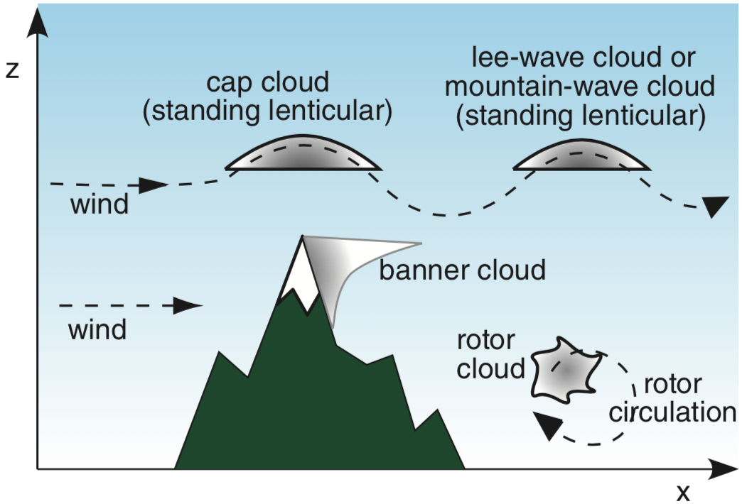
Lenticular
| “Bubble shape” little ufo’s | Wind oscillations, may indicate mountain wind turbulence |
Rotor
| Ragged looking under mountain | Ragged looking cloud that forms that form at low altitude under crests of mountain waves
|
Banner
| Like a banner blowing off the mountain | Indicate strong turbulance, usually only on an isolated peak |
Pyrocumulus
| Its over a big fire or volcano lol | Heat and moisture released so strong it can make a thudnderstorm |
Pileus
| Like a little hat on a cumulus | Form over fast growing cumulus clouds |
Fractus(scud)
| Ragged and low | Turbulent humid air near ground, indicate high humidity and strong winds |
Fumulus
| Above smoke stacks | Water droplets condense over cooling towers |
Contrails
| Trails behind airplanes | From wing-tip vortices on airplanes |
1c. Relate cloud coverage amounts to the visual appearance of the sky.
Coverage | Oktas (eighths of the sky covered) | Code |
Sky clear (nothing) | 0/8 | SKC |
Few clouds (small trails) | 1/8,2/8 | FEW |
Scattered (large gaps) | 3/8, 4/8 | SCT |
Broken (small gaps) | 5/8, 6/8, 7/8 | BKN |
Overcast (no gaps) | 8/8 | OVC |
Flying at altitude just above or just below a the level of clouds make them appear to have more coverage than they actually do
1d. Define the cloud ceiling, estimate its altitude, and relate it to cloud coverage amounts.
Clouds that cover more than half the sky create a cloud ceiling, constraints VFR pilots to fly below it and
When ground visibility is very poor, referred to as vertical visibility
IFR pilots are still concerned with ceilings, to be able to approach airport with sufficient time to plan a landing
Can estimate cloud ceiling using known landmarks such as mountains, pole or tree tops
1e. Contrast horizontal visibility, vertical visibility, and runway visual range (RVR), and discuss how they affect aviation.
Three types of visibility and each have their own way of measuring
Horizontal
Distance you can see horizontally
Distance between when pilot sees a hazard and when plane hits hazard is affected by horizontal visibility
Vertical
Distance you can see vertically high or height of the cloud ceiling
Runway Visual Range
Measured at airports, how far ahead a pilot can see along a runway centerline
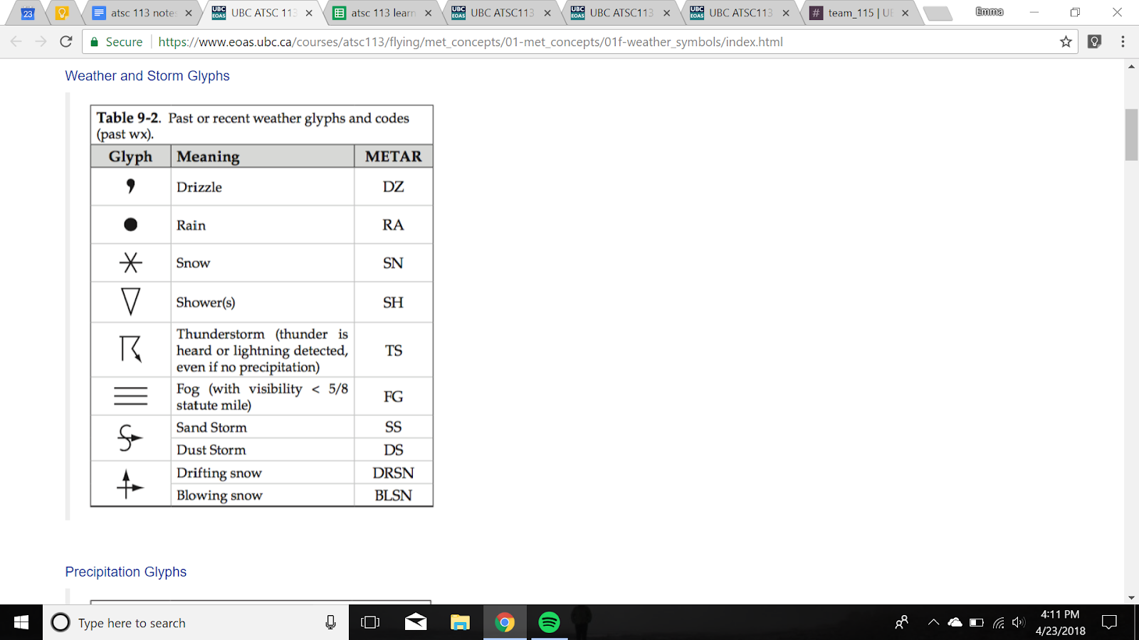
1f. Recognize and interpret weather and obscuration glyphs on weather charts.

1g. Explain the difference between visual & instrument flight rules (VFR, IFR) and meteorological conditions (VFC, IFC), and how they affect aviation.
Visual Flight Rules
Only flown in visual flight conditions or Visual Meteorological conditions.
More than 3000 ft AGL ceiling
More than 5SM visibility
No instruments, lookout windows.
Hazards like fog, clouds, heavy precip
Marginal VFR is when it’s close call
Between 1000 and 3000 ft AGL ceiling
Between 3 and 5 SM visibility
VFR “over the top” is
Instrumental Flight Rules
Conduct most of flight without looking out the window
Can fly in good weather and bad weather
Instrumental Meteorological Conditions
Less than 1000 ft AGL ceiling
Less than 3 SM visibility
1h. Anticipate when fog might occur based on location, humidity, temperature, winds, and cloud cover, and how fog affects aviation.
Fog is a cloud that touches the ground
Water droplets falling so slowly they seem suspended
Forms when:
Water is added to unsaturated air
Unsaturated air is cooled to its dew-point temperature
When ground warms the air above it!!!
Fog is denser and flows downhill
Forms in these conditions:
Most often late at night or early morning as cool ground cools air
Nights with clear skies more likely than anything else
Radiation: cooling at night
Advection: humid air blows over a cold surface (lake, snow, ocean)
Upslope: Upwards moving air cools against a slope (mountain, hill)
Precip or frontal: adding moisture, via evaporation from warm rain drops falling down through cold air below cloud
Steam: cold air moves over hot surface (cooling pong, warmed fields)
Hazards:
Visibility hazard
Can dissipate or lift
Hard to forecast
1i. Explain the nature of these obscurations: haze, smoke, blowing dust/sand, blowing snow, volcanic ash, rain, and how they affect aviation.
Name | Formation | Affects aviation |
Haze | Microscopic water droplets forming around a pollutant particle | Reduced visibility |
Smoke | Forest fires | Visibility and smoke entering cabin |
Blowing dust/sand | Strong winds around deserts and sandy areas makes a…. haboob | Threat to machinery, sandblasting. Great reduction to visibility |
Blowing snow | Its snow | Visibility |
Volcanic ash | Volcano | Threat to engines, machinery of aircraft. Can melt and fuse as glass. |
Rain | Its rain | Light and moderate, reduced visibilities. Heavy rain reduces vis to point of no safety. Fly around or IFR. |
Topic 2: Pressure, Temperature, Winds & Wind Shear
2a. Draw the variation of pressure & density with altitude
Pressure and density decrease smoothly with increase in altitude
2b. Explain how reduced oxygen at high altitude affects pilot physiology
Reduced atmospheric density reduces the amount of oxygen a pilot gets.
At certain altitudes a pilot will get hypoxia
Between 12k and 15k feet: Impaired memory, thought process, reaction time, alertness, coordination. Euphoria, dizziness, drowsiness.
Above 15k feet: vision impaired, lips and fingers blue, unconsciousness, death
Solutions:
Above 13k, oxygen mask
Above 40k, pressurized oxygen
Above 62k, pressure suit
2c. Explain how and why pilots use “density altitude”
Thinner air reduces airplane performance, such as ability to take off and gain altitude
If low-altitude air is hot enough it can act like a lower density
Pilots consider density altitude before taking off
Depends on temperature and altitude
Adjusts pressure for temp.
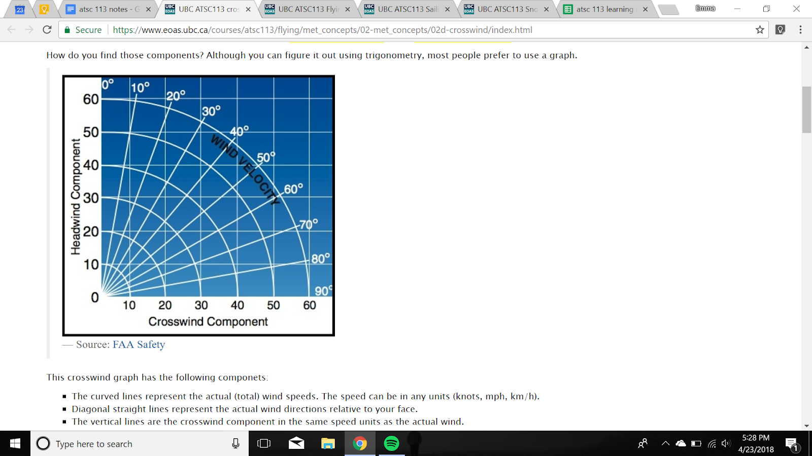
2d. Compute crosswind & headwind components
2e. Identify the causes and typical locations of wind shear at aerodromes
Change of wind speed or direction with altitude
Almost always present near ground
Strong wind shear near the ground at airports make it hard to land
Caused by: (as well as others)
Caused by weather systems
Caused by winds flowing across mountains
Turbulence behinds obstacles
Caused by other large aircraft taking off/ landing
2f. Relate updrafts for soaring to causes including thermals, anabatic winds, and mountain waves
Gliders use updrafts to fly
The following produce updrafts:
Mountain waves
Thermals
Sun heats ground, warm air rises in a thermal
Anabatic winds
Warm updrafts along mountain slopes
Anabatic cumulus can form at top
Topic 3: Turbulence & Icing
3a. Identify atmospheric layers according to temperature characteristics in the standard atmosphere
Remember pressure and density decrease smoothly with increase in altitude
Standard atmosphere is not adjusted for local conditions, just gives average
Temperature does not decrease smoothly at all altitudes
Regions of increase and regions of decrease, which define the main layers of the atmosphere
Name | Top | Description | Altitude | Temp w alt. |
Troposphere | Tropopause | Almost all weather occurs here. Almost all aircraft fly here. | 0-11km | Decreasing |
Stratosphere | Stratopause | Constant temp the increases due to good ozone layer. Some planes fly here to avoid weather. | 11-47 km | Increasing |
Mesosphere | Mesopause | 45-85km | Decrease | |
Thermosphere | Exobase (to exosphere) | Molecules are so spread out do not act like gas. | 85+km | Increase |
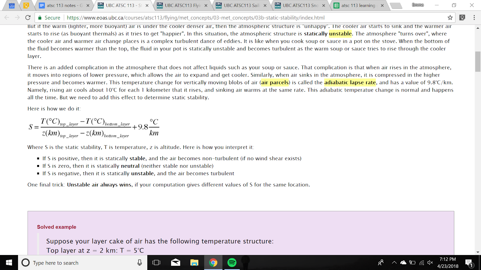
3b. Determine the static stability given temperature soundings, and describe its effects on air motions and on aviation
Atmospheric stability tells weather the air will become or stay turbulent or non-turbulent (unstable / stable->(laminar))
Stable-> no turbulence
Unstable -> turbulence
Turbulence ranges from eddies to thermals to thunderstorms.
Static stability relies only on the temperature layering and not the wind
If S is > 0 it is stable, =0 it is neutral, negative it is unstable
If multiple layers give “competing answers” (one stable one unstable) unstable always wins.
Unstable typically occur when it’s hot and the ground gets hot and makes all the air unstable
3c. Describe how different types of turbulence form, and relate turbulence intensities to aircraft behavior
Three types of turbulence:
convective turbulence, or free convection, or thermal turbulence (due to buoyancy: warm air rising and cold air sinking)
wind-shear turbulence, or forced convection, or mechanical turbulence (different wind speeds or wind directions at different altitudes)
obstacle turbulence (caused by wind hitting an object and flowing around it)
Intensity | Aircraft Reaction | Inside Aircraft |
Light | Slight changes | Slight strain in seatbelts, little to no trouble walking |
Moderate | Changes but aircraft is in control, rapid bumps or jolts | Definite strain against seatbelts, objects are dislodged, difficulty walking |
Severe | Large abrupt changes in altitude, momentarily out of control | Forced violently against seatbelts, walking is impossible, objects thrown about |
3d. Describe the characteristics and causes of mountain waves, relate them to winds and stability, and describe how they affect flight
When air flows over a mountain in stable air (hot over cold) it can oscillate up and down creating waves in the atmosphere
Froude number describes the behaviour of the waves
When froude = 1 the waves are the most violent as the width of the mountain
Makes airplane go up and down “chop”. Must make corrections to remain at one altitude. Can change too fast to keep up with.
3e. Describe the characteristics and causes of clear-air turbulence (CAT), and relate them to winds shear & stability
When wind shear turbulence happens outside of a thunderstorm system and nowhere near it
Can happen at any altitude but is strongest when winds are strongest, eg. in the jet stream
Cat’s are thin and flat, like a pancake in the sky, can get out by flying up or down
Forms when there is a wind shear across a statically stable region, interference between two layers creates Kelvin Helmholtz
3f. Compare the characteristics and causes of boundary-layer & obstacle/mountain-wake turbulence, and describe their effects on aviation
Boundary layer turbulence:
Clear air buoyant updrafts and downdrafts create wind shear interference and turbulence in the atmospheric boundary layer and planetary boundary layer
Weak and moderate, not hazard
Obstacle/mountain-wake turbulence
Downwind turbulence forms around larges object form with strong winds and unstable air
3g. Explain how and where supercooled water forms, and explain how ice on aircraft affects flight.
Water not in ice form in the atmosphere, will turn to ice as soon as it touches anything
Forms between 0 and -40 degrees
Flights from 2.5 to 8.5 km in altitude can have droplets freeze on airplane
Lift decreases, weight increases, drag increases, thrust decreases. They are cumulative!! One makes the others worse that makes the others worse
Ice breaks off and hits plane
On windscreen cant see
3h. Locate likely areas of turbulence, icing, and thunderstorms relative to warm, cold, occluded fronts, and dry lines, and describe how these frontal hazards affect aviation
Boundary between warm and cold weather is a front
Occluded fronts
come in two flavors: cold occlusions and warm occlusions.
occur when a cold front catches up to a warm front.
If the advancing cold front has colder air that is retreating ahead of the warm front, then the result is a cold occlusion. Otherwise, it is a warm occlusion.
The resulting clouds and weather are a combination of widespread stratiform drizzle and focused intense thunderstorms. Namely, an IFR pilot could encounter dangerous thunderstorms embedded in gentle stratus clouds. Or a VFR pilot could be flying between stratiform layers and have part of the route blocked by a thunderstorm updraft tower (see figures below).
The warmest air between the cold and warm fronts is pushed upward above the collision between the cold and cool air, causing fronts aloft.
Cold fronts:
winds coming from deflected around front
Bring thunderstorms and clear skies
Pointy line
Warm front:
Winds deflected around
Bring rain and cirrus clouds
Dry lines
Boundary between dry and humid air of the same temperature
Triggers thunderstorms like cold front
Frontal hazards
Icing hazards
Thunderstorm hazards
Strong winds
Visibility
Drylines super big thunderstorm
Topic 4: Thunderstorms & Aviation Weather Services
4a. Describe thunderstorm cells, the different types of thunderstorms, and their hazards to aviation.
Thunderstorms are made of cells, each like it’s own thunderstorm
Evolution: Cumulus -> Mature -> Dissipating -> Residue
Basic storms | |
Single-cell air mass | Short lived and non-violent |
Multicell | Two or more cells, each can be in it’s own life stage and hazards |
Orthographic | Forms over mountains when warm air rises up slope |
Mesoscale convective systems (more than one storm) | |
Squall line | Wall of thunderstorms shoulder to shoulder along cold front along a cold front |
Bow-echo | A line of thunderstorms is bent into an arc or bow shape by fast winds from behind, called the rear inflow jet (RIJ) |
Mesoscale Convective Complex | This is a line or region of strong thunderstorm cells with heavy rain, followed by moderate and lighter rain extending over a broad region. |
Mesoscale Convective Vortex (MCV) | If MCC dissipates late at night, remaining non-stormy clouds at middle altitudes (~5 km above ground) have a very slow rotation counterclockwise around where the center of the MCC was. |
Supercells (most dangerous and longest lived, possibility of tornado) | |
Low-precipitation (LP) Supercell | Although LP storms do not have much rain, they can produce large hail and downburst winds. |
Classic supercell | complex interplay of winds and rain, making flight near all supercells extremely dangerous. Classic supercells can have a hook-echo shape. |
High-precipitation supercell | Much more extensive rain. Rain curtains hide tornado. |
4b-h. Identify thunderstorm hazards to flight & how to avoid them.
Do not fly through thunderstorms, 20 nautical miles away
Hazard | Why | Avoid |
Convective Turbulence | Because thunderstorms are convective clouds they are driven by the buoyancy of warm air rising inside the cloud. Random fluctuations in this create turbulence. Many eddies superimposed. Don’t fly in sucker hole, lots of CAT. | Don’t fly into thunderstorm, 20 nautical miles away. |
Downbursts | Strongly descending burst of air from clouds with precipitation. When they hit ground spread out as outflow winds. Leading edge is gust front. Small downbursts (in duration) are microbursts. Gust front is the front of outflow winds. Can make haboob in desert. | Turbulence and pushing towards ground, avoid by approaching runway faster or entering holding pattern. |
Lightning and P-static | Spark created in a thunderstorm, due to collisions of graupel. St.elmo’s fire is corona discharge on windscreen. No harm but can cause static on radio. | Lightning strikes very rarely damage plane. Turn up lights in cockpit to avoid blindness. Pstatic affected radio communications. |
Hail | Ice stones, path of destruction is hail swath. Hail only forms in large supercells because the upwards speed of the updraft must exceed the terminal velocity of the hailstone. | Extremely dangerous to aircraft, can break windscreen and damage other. Can be carried out of anvil and land far away. |
Tornadoes | Rapidly spinning air between cumulus and ground. Most come from supercells. | Hard to predict, stay out of thunderstorms. |
Heavy rain | Rain is not hazard except for downbursts but heavy rain reduces visibility. VFR fly around except for squall line. | Stay away |
4i. Access government sources of aviation weather observations, analyses, and forecasts.
METAR is current observed weather at airports every hour.
SPECI is conditions in between METARs
TAF’s are forecasts of future weather.
All can be encoded or in plain english.
Snow sports weather
Topic 5: Winter Weather
5a. Interpret temperatures from pressure-level maps.
Pressure gives you elevation, temp contour lines give you temp.
Pressure is used as analog for elevation, higher up lower pressure numbers.
5b. Interpret winds from pressure-level weather maps in terms of ski safety
Wind is shown with wind barbs
Line shows you which directions
More barbs the stronger the wind
Half barb: 10 km/h
Whole barb: 20 km/h
Flags: 100 km/h
5c. Interpret clouds and moisture from pressure-level maps.
Clouds are not plotted, but relative humidity is (percent of moisture that air can hold that is currently holds) that can be used to infer clouds.
Less than 50%: confident there will be no clouds
Starts forming clouds at 70%
For sure overcast at 90% and above, little to no visibility.
5d/m. Identify lows and troughs on sea level pressure maps. List weather conditions relating to low pressure that are hazardous to skiers.
Low pressure systems (cyclones) are associated with bad weather
Heavy precipitation
Strong winds
Low visibility
Winds converge towards the center of a Low, since winds blow from high to low pressure. Coriolis turns air to the right that creates a cyclone.
Converging air only has one place to go: up. Creates updraft which creates cumulus convective clouds.
Region where pressure is lower than surrounding areas
Place “L” on map where all pressure around it is increasing (completely surrounded with high pressure)
5e/i. Use your knowledge of mean sea level pressure to identify high pressure systems and ridges on pressure maps. List the weather conditions associated with a high pressure system and their relevance to snow sports.
Place “H” on map where all pressure around it is decreasing (completely surrounded with low pressure)
High pressure (anticyclone) is associated with good weather.
Pressure differences are typically fairly weak under high pressure, so winds tend to be lighter.
Typically associated with dry conditions, clearer skies, and a lack of precipitation.
Wear sunscreen!, occasionally strong winds.
5f. Identify the location of cold and warm fronts using multiple weather maps.
Fronts identified by lines closer together on temp maps.
Cold front pointy
Warm front circles
5g. List the weather conditions associated with cold fronts that affect snow sports.
Temperatures colder behind a cold front
Winds are strong near fronts, colds more so
Bring line of precipitation then scattered behind
Hurts visibility: Blowing snow, clouds, precip
5h. List the weather conditions associated with a warm front that affect snow sports.
Temperature changes can freeze/melt snow on ground or in air
Warm fronts bring mixed precipitation and clouds
Low visibility
5j.Use wind and pressure maps to predict large-scale surface high winds.
More barbs = more wind
Strong pressure gradient, more wind
5k. Use wind and pressure maps to predict ares of light/calm winds.
With weak pressure gradient, less wind
Pressure drives airflow from high to low
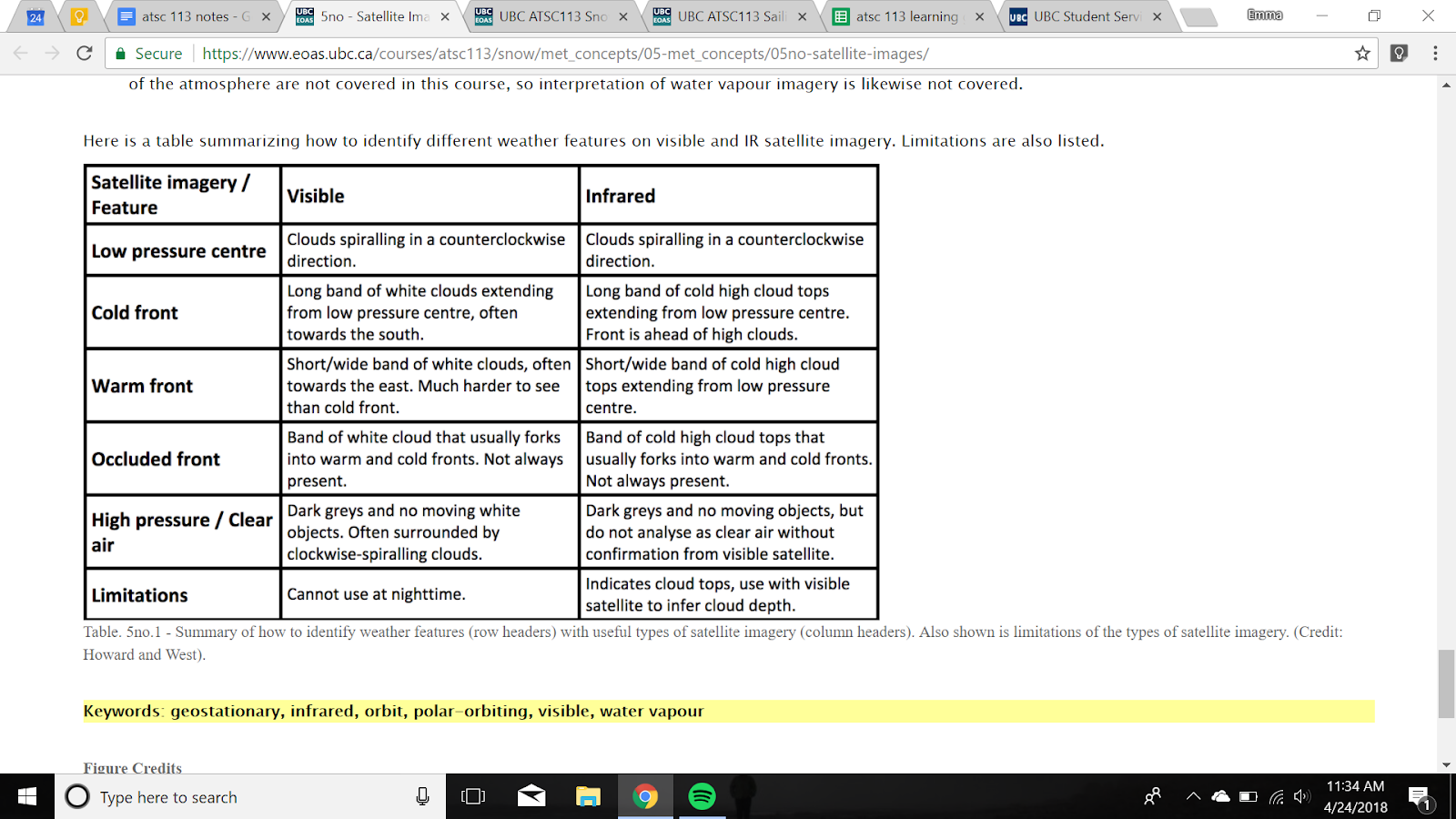
5n/o. Explain the limitations of different types of satellite imagery. Use satellite imagery to identify low pressure systems, fronts, and fair weather.
Three satellite types:
Visibile
Black and white photo from space
Cannot use at night
Infrared
Indicated cloud tops only not cloud depth
Water vapour
Topic 6: Winter Mountain Weather
6a. Explain the causes and effects of cold air pooling
When there is high pressure with a stable air profile cold air pooling can occur. Mostly at night but can last into the day.
Cold air just above the surface pools
Hazards are very cold air in valleys and valley bottoms
Cold air drainage flows adding to wind chill
Valley cloud/ fog limits visibility
Freezing fog when temp within fog are below freezing
Plan to camp/ stay above this level
Strengthens inversions
Flows create katabatic winds
6b. Describe the diurnal evolution of slope flows
Happens on a daily basis, the cycle of katabatic and anabatic winds
Sun heats up air on slopes and it flows up in anabatic winds
Can form cumulus cloud over mountain top
Can help dissipate pools and valley fog
Night cools air along slopes and it flows into valleys as katabatic winds
6c. Explain what a temperature inversion is and why it is important to mountain recreation
When temperature increases with elevation increase in the troposphere it is known as an inversion.
Occurs due to relative cooling of the ground
Subsidence due to high pressure
When an inversion is present the air is very stable as hot air is on top.
Because of the adiabatic lapse rate, even if the temperature decreases slowly with height, i.e. the air near the surface is very slightly warmer than air above it, it’s also considered stable, though not as stable as when there is an inversion.
If you don’t know can bring unexpected temperatures
Affects snowpack
Can trap moisture in the valley, then creates valley fog
6d. Identify conditions that favour valley cloud/fog formation and dissipation
Occurs due to:
Inversions
Cold air pooling
Katabatic winds
Downslope flow
Dissipates due to
Sunlight breaking the inversion
Marine clouds can move in from the ocean
6e. Explain orographic lift and lee shadowing.

6f. Identify and explain areas in the mountains that are likely to be wind-exposed.
Wind exposed areas are peaks and ridges of mountains, most extreme volcanoes
Fast winds hit mountains peaks head on
Friction from other peaks may slow down some winds
6g. Identify and describe areas in the mountains that are likely to be wind-sheltered.
Mountain valleys, treed areas
6h/i. Determine the temperature at your elevation from pressure-level maps and adjust
Two step process:
1. vertically interpolate temperature from a pressure level map
2. Make adjustment to that temperature from based on heating or cooling from ground surface
Choose adiabatic lapse rate:
Dry when below 80% saturation, strong winds, daytime in spring,
Decrease of 10 degrees per 1000m
Wet when 80% humidity or more
Decrease of 6 degrees per 1000m
Make sun heating/ cooling adjustments
Sun angle
Cloud cover
Wind speed
6j. Identify hot and cold conditions from observations.
Cold below -15 warm above 5.
Unseasonably warm or cold
6l. Recognize the large-scale weather pattern associated with Arctic air and outflow
Originates from the arctic from high pressure system
Very cold stable and dense.
“Flood” of air coming down across prairies
“Arctic fronts” look like cold fronts passing from eastern to western BC
6m. Describe and explain terrain channelling of winds and why this affects skiing
Large scale winds are altered by terrain, channelled along valleys.
Gap winds are when large scale wind is perpendicular to mountain range.
Faster winds in smaller gaps
Brings colder temps, higher wind speed and changes wind sheltered areas.
Topic 7: Snow Conditions
7a. Identify and forecast the freezing level and when precipitation will fall as rain vs. snow.
rain-snow line is defined as the elevation at which precipitation type transitions from rain to snow
Not typically same as freezing level
To forecast rain-snow line find elevation of freezing level then subtract 300-200m
7b. Define snow density and describe what conditions will lead to high vs. low density newly-fallen snow, and why this matters to skiers.
Snow density is amount of mass and ice per volume
High density:
The warmer temperature the higher the density
High wind speeds higher density
Low density:
Colder temperatures
Slower wind speeds
Low density is better for skiing then high density
7c. Describe right-side-up and upside-down snowfall and their significance to skiing and avalanches
Right-side-up snowpack
High density below low density
Good for skiing, vertical gradient lifts skiis up
Upside-down snowpack
Low density below high density
Hard to ski
More likely to have avanlanches
7d/e. Explain the factors that influence snowpack evolution. List the conditions that are favourable for rounding and faceting snow crystals.
Snowpack temperature gradient is the most important factor in determining the snowpack evolution
Faceted crystals
produced with a strong vertical temperature gradient.
Lots of space between crystals
More avalanche risk
Rounded crystals
When vertical temp gradient is weak
Tightly packed snow
7f. Describe the properties of a stable and an unstable snowpack and how to assess stability
Determine stability of snow by snow pit and measuring snow hardness using hand test
Stable has weaker layers on top of stronger layers
Weakly bonded layers
Undergone faceting
Surface hoars
New fallen low density snow
Strongly bonded snow layers
Old stellar dendrites that are now rounded crytals
More dense and hard with more and stronger bonds
Crust layers
Rain crust by rain on snow
Surface level melts then re-freezes
Sun crust if sun does it
7g. List characteristics and geographic regions of coastal, continental, and transitional snow climates.
Coastal: western side of coast in northern hemisphere. Moisture from ocean
Frequent snowfall with a lot of snow
High density
Warm temperatures
Low avanlanche danger
Transitional: mixture of maritime and continental snow climate, just inland from coast
Frequent snowfall with moderate amounts of snow
Moderate density
Lower avanlanche danger
Continental snow climate: far inland away from moisture sources
Low snowfall
Low density snow
Persistent weak layers
Higher avalanche danger
7h. Describe the effects of aspect on surface snow evolution
The angle the sun hit the snow determines how much energy is transferred to the snow.
Certain sides of mountains get more sun than others
7i. Describe the atmospheric conditions for surface hoar formation and how this might lead to an avalanche
Formation of ice crystals on top of a snow surface
Clear skies
Calm winds
Strong temperature inversion
Can cause slab avalanches or persistent weak layers
7j. Define an avalanche, and list and describe types of avalanches.
Mass of snow that moves quickly down a mountain
Loose snow (sluff)
Surface or near surface snow that is not well bonded
Begin at single point and get more snow
Comprised of loose snow
V shape
Not usually very dangerous
Wet or dry
Slab avalanche
Layer below surface layer fails
Comprised of cohesive blocks
Wet can occur in spring
7k/l. Identify different snow crystal habits by sight. Give reasons why snow crystal habits form differently.
Stellar dendrites: typical snowflake
Columns and needles: look like name
Capped columns: look like I beams
Diamond dust: small and fun shapes
Graupel: little balls
Aggregates: like cotton candy
Form differently due to humidity and temperature. Temperature makes them cycle, more humidity makes them bigger.
7m/n. Describe what makes an optimal ski run for recreation and racing. List and explain ways that mountain operators reinforce the snowpack hardness on a recreational and racing ski piste
Optimal ski run:
Safe, smooth, durable, interesting, visually attractive, good grip, hard
To harden ski piste: Grooming machine, man made snow,water injection, chemicals
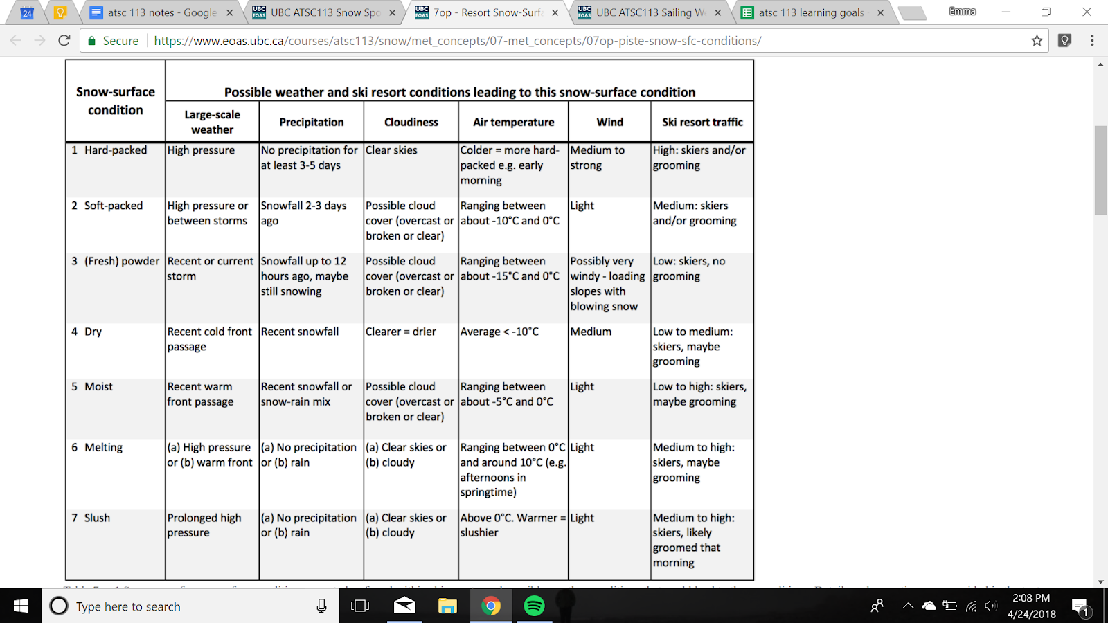
7o/p. List possible snow-surface conditions found in ski resorts and describe a possible weather scenario that leads to each condition. Give reasons why snow-surface conditions are important to ski racers and recreational skiers.
SAILING WEATHER
Topic 8: Winds and Waves
8a. Describe the relationship between wind velocity, fetch, and duration, and how drag is created between the ocean and the atmosphere.
Three main factors in wave formation: wind velocity (speed wind blows over water), fetch (distance over water wind can blow uninterrupted) and duration (amount of time wind blows over a patch of water). Need all 3 for big waves.
When wind blows across ocean it makes drag that acts against the relative motion of the two fluids. Energy from drag transferred to mechanical that makes waves.
8b. Describe the relationships between wave characteristics including shape, wavelength, period, amplitude, steepness, phase and group velocities, and wave trains. Explain how wind-generated waves, swell, rogue waves, and tsunamis are formed.
Steepness: ratio of wave height to wavelength
Wind-generated: wind disturbing surface. Restored by capillary and gravity.
Swells: large waves originating from far out in the ocean
Rogue waves: large waves that form due to interference
Tsunamis: seismic events
8c. Explain how wave characteristics determine the types of breaking waves.
When wave steepness exceeds 1:7 the wave will break.
Spilling breakers when waves travel across sloping bottom
Plunging breakers: Moderate to steep bottoms
Surging breakers: Steep shores
8d. Explain the parameters that need to be considered when forecasting swell from distant storms.
Swell direction: angle at which it is coming from and how they will hit boat
Wave height and period
Local winds: can influence swell
Tide
Swell refractions: some parts of wave have more drag than other
Swell decay: how fast it loses energy
8e. Explain the change in wind speeds and sea state as you move along the Beaufort Wind Force Scale
Scale from 0-12 to describe strength of wind based on visual effects at sea or land
0 is calm 12 is hurricane
Topic 9: Large-Scale Winds
9a. Identify the global wind circulations: Hadley cell, mid-latitude belt of cyclones, and Polar cell. Describe how the trade winds, westerlies, and easterlies are influenced by the Coriolis effect
Global wind circulations: Hadley cell, mid-latitude belt of cyclones, and Polar cell
Wind blows diff directions in northern and southern hemispheres due to coriolis effect
9b. Describe the location of the jet streams in relation to the global circulations and explain how the ridges and troughs in jet streams influence surface weather.
Jet streams are fast flowing, narrow bands of wind in the upper atmosphere that circle their way around the globe. The two major jet streams form where air masses of different temperatures converge. The greater the difference in temperature, the stronger the winds. The jet stream that forms near 60° latitude is called the polar jet stream, while the one that forms at the poleward limit of the Hadley cell is called the subtropical jet stream.
Jet streams have a strong influence on local weather because mid-latitude cyclones (surface Lows and their fronts and bad weather) are created on the east side of jet-stream troughs (about halfway between the trough axis and the ridge).
a jet-stream trough (low pressure) just west of your location is often associated with locally bad weather (clouds, precipitation, strong winds often from south-east through south-west). But a jet-stream ridge (high pressure) just west of your location is associated with good weather (light winds from the north-west through north-east), mostly clear skies).
9c. Describe how the trade winds influence the Walker cell and the El Niño-Southern Oscillation.
The longitudinal circulation across the equatorial Pacific is known as the Walker cell
These trade winds push the cooler water from the eastern Pacific all the way across the equator to the west Pacific, warming as it goes. The warm air over the warmer west Pacific waters rises, losing its moisture as precipitation. The dryer air then travels back towards the eastern Pacific, creating a loop. This cool Pacific air then converges with cool continental air and sinks along the eastern Pacific coast.
The neutral phase is the Walker cell functioning normally, while El Niño is the warmer phase of ENSO and La Niña is the cooler phase.
An El Niño phase occurs when the trade winds weaken
The La Niña phase occurs when trade winds are stronger than normal, causing increased upwelling of cool waters along the eastern Pacific and more cold water being pushed further across the Pacific.
9d. Explain the global ocean surface currents and how they are affected by wind.
The ocean’s surface currents are driven predominantly by frictional drag from the global winds
The global ocean surface currents regulate the global climate. The oceans absorb a great deal of solar energy, and surface currents help to redistribute that energy around the world.
9e. Describe how and where hurricanes form and the influence of the Intertropical Convergence Zone and easterly waves on their formation.
only forms within warm tropical air masses located between the Tropic of Cancer (23.5o N) and the Tropic of Capricorn (23.5o S)
created by the energy or latent heat that is released as moist, warm air rises
he Intertropical Convergence Zone (ITCZ) occurs near the equator where the north easterly and south easterly trade winds meet. The location of the ITCZ shifts north in our summer months and south during our winter months so that it remains beneath the high sun. Because of this, large amounts of energy are available to evaporate large amounts of water, creating precipitation and thunderstorms. These storms supply the tropics with the majority of their precipitation. Sometimes, a cluster of these thunderstorms will develop into a hurricane as they build and move away from the ITCZ.
Easterly waves are the cause of many tropical storms, particularly those off the eastern United States. An easterly wave takes the form of a trough of low pressure. In satellite imagery, it might look like an inverted V. You will typically see fair weather on the west side of the wave and heavy rain, clouds, and thunderstorms to the east.
9f. Describe the characteristics of extratropical cyclones, sting jets, squall lines, waterspouts, and downbursts.
Extratropical cyclones are cyclones that form outside of the tropical or mid-latitude zones, typically between 30o and 60o latitude. can cause both mild (e.g. showers) and severe weather (e.g. thunderstorms). During the transition, the hurricane connects with other fronts or low pressure troughs.
Sting jets are a rare phenomenon that can be produced by specific type of extratropical cyclone in which the warm and cold fronts never meet. The sting jet forms as strong winds start to descend towards the ground, drying and evaporating as they fall, become denser and faster. strikes a relatively small area on the ground, but leaves immense devastation.
Squall line is a long chain of thunderstorms that forms on, or ahead of, a cold front. They form as air near the front lifts along a common lifting mechanism, such as another front or an outflow boundary. Heavy rain, thunder, lightning.
Waterspout is a spiralling column of air and moisture that develops over water beneath a cumuliform or cumulonimbus cloud.
9g. Describe what different weather systems (ie. High and low pressure, warm and cold fronts) look like when you’re on the water; and Describe the effects that tide and current can have on your travel speed and access to certain areas.
Travelling with currents and tides helps
Topic 10: Local Winds and Gusts
10a. Explain when and where you would expect to see sea and land breezes and katabatic winds.
Temperature differences between land and sea create sea and land breezes. During the day, both the land and the water absorb energy, or heat, from the sun; their capacity to absorb heat. The sea absorbs and releases the heat slowly, whereas the land absorbs and releases heat quickly. During a sunny afternoon, the air over the land will become warmer than the air over the sea, creating areas of low and high pressure respectively. Air moves from high to low pressure, and so the cooler air blows onshore. This is called a sea breeze.
10b. Describe how inflow and outflow winds work in a coastal inlet
Inflows and outflows: Local land features can create localized wind patterns. Fjords and inlets reaching from the coast to the interior act like highways carrying winds to and from coast.
10c. Identify areas of mesoscale cellular convection (open and closed cells) and horizontal roll vortices in satellite imagery and describe how they are formed.
Mesoscale cellular convection occurs in the boundary layer between the Earth’s surface and the troposphere. It is most common over the oceans, where colder air from the continents blows out over the warmer ocean air. This process is known as cold-air advection. As warm air converges on the ground, it rises a few kilometers and spreads sideways. An adjacent cell does the same and the higher air spreads until they meet. The converging air between the two cells is then forced to sink. This pattern of convergence and divergence creates a honeycomb pattern of convective clouds that are recognized as open or closed cells.
Horizontal roll vortices, also known as cloud streets, are another product of cold-air advection and temperature inversion. They are called cloud streets because of the long rows of cumulus clouds that form due to the movement of convective currents below the inversion. Due to the force of the wind and the friction between air masses, the warm air curves as it rises, creating a roll. Warm air rises to the bottom of the inversion and forms clouds before spreading horizontally and descending back down to the water in a rolling pattern.
10d. Describe the forces that drive tidal cycles and how tides relate to currents.
The tide is the movement of the Earth’s oceans up and down due to the gravitational pull of the moon and sun.
Rising and falling of tides creates tide currents
10e. Describe the processes that drive coastal upwelling, and explain how upwelling and sea surface temperatures create fog.
Upwelling is the rise of cold, nutrient-rich water from the depths to the ocean’s surface. Similar to ocean currents, it is influenced by winds, the Coriolis effect, and Ekman transport
Sea fog is a type of advection fog, forming when warm, humid air travels over a cooler surface, in this case water. As the warm and humid summer air passes over the cold water recently risen from the deep ocean, it cools and condenses, forming fog over the water.
10f.Recognize optical phenomena over the sea, including mirages, fata morgana, and the green flash.
Mirages are created when light passes through air of different densities.
Fata Morgana: temperature inversion is not even
Green flash: during sunset green light is dispersed
11a. Determine the short-term and extended marine forecast for a given location.
11b.Relate weather warnings to wind speeds to make decisions about your sail plan.
Strong Wind Warning: 20-33 kn winds
Gale Warning: 34-47 kn winds
Storm Warning: 48-63 kn winds
Hurricane Force Wind Warning: >64 kn winds
Squall Warning: gusts > 34 kn associated with a squall line, or line of storm clouds
Freezing Spray Warning: risk of ice formation due to low temperatures, strong winds
Waterspout Warning: given when a waterspout has been detected by radar or by observers